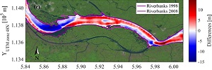
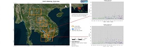
Processing and analysis of available hydrological and topographic/bathymetric datasets
For the set-up of hydromorphological numerical models of the Mekong River, datasets of hydrological parameters (discharge, water level) and topography/bathymetry (see Figure 1) have been collected, processed and analyzed by the Ludwig-Franzius-Institute (LuFI).
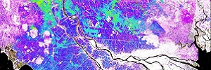
Mutli-sensor satellite approach used for flood mapping
Optical and radar data from Sentinel-1, Sentinel-2 and Landsat of the hydrological year 2016/2017 have been used to derive a high-resolution flood frequency map for the entire Mekong Delta.
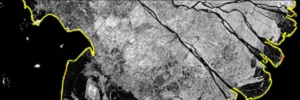
Long-term coastal morphological changes quantified for the entire Mekong Delta
Scientists from University Wurzburg recently evaluated long-term coastal morphological changes for the entire Mekong Delta in Vietnam. On the basis of SPOT-5 satellite images from 2003 and Sentinel-2 data from 2017, shoreline erosion and land loss as well as accretion processes through sedimentation were quantified every 500m for the entire coastline of the Delta.
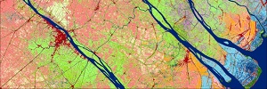
European satellite data used for high-resolution land use mapping
The European Copernicus Mission provides free satellite data for earth observation mapping and monitoring. DLR used all available Sentinel 2 satellite data of 2016 to derive 20 LULC types for the Mekong Delta region.
Generation of Total Suspended Matter Time Series from Landsat Satellite Data Archive
EOMAP processed all available satellite imagery from the Landsat archive for the whole mid- and downstream section of the Mekong River to derive time series information on water quality parameters.
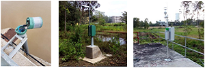
Measurement network in operation in the Mekong Delta
A measurement network developed in the Catch-Mekong project was installed in the Mekong Delta.